Hurricane Andrew
| Category 5 hurricane (SSHS) | ||
|---|---|---|
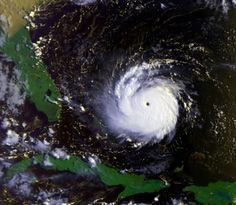 Hurricane Andrew approaching the Bahamas and Florida as a Category 5 hurricane |
||
| Formed | August 16, 1992 | |
| Dissipated | August 28, 1992 | |
| Highest winds |
|
|
| Lowest pressure | 922 mbar (hPa; 27.23 inHg) | |
| Fatalities | 26 direct, 39 indirect | |
| Damage | $26.5 billion (1992 USD) $41.6 billion (2010 USD) (Second costliest tropical cyclone in U.S. history) |
|
| Areas affected |
Bahamas; South Florida, Louisiana, and other areas of the Southern United States | |
| Part of the 1992 Atlantic hurricane season |
||
Hurricane Andrew was the third most powerful Category 5 hurricane to make landfall in the United States during the 20th century, after the Labor Day Hurricane of 1935 and Hurricane Camille in 1969. Andrew caused over 10,000 deaths along its path.[1]
Andrew was the first named storm and only major hurricane of the otherwise inactive 1992 Atlantic hurricane season. During Andrew's duration it struck the northwestern Bahamas, southern Florida at Homestead (south of Miami), and southwest Louisiana around Morgan City in August.[2] Andrew caused $26.5 billion in damage ($41.5 billion 2011 USD), with most of that damage cost in south Florida; however, other sources estimated the total cost between $27 billion to $34 billion. Its central pressure ranks as fourth-lowest in U.S. landfall records and Andrew was the costliest Atlantic hurricane in U.S. history until surpassed by Hurricane Katrina in 2005. It was one of two intense hurricanes to strike the United States that year; Hurricane Iniki in the Central Pacific struck Hawaii and the Hawaiian Islands a few weeks later as a Category 4 hurricane.
Contents |
Background
At the time Andrew was the eighth major hurricane to affect the Florida peninsula in over twenty-five years. Hurricane Donna of 1960 had been the last major storm to pass directly over south Florida peninsula, making two landfalls: one over the Keys; and the second over Naples, located on the state's west coast. After landfall Donna moved northeast, diagonally crossing Florida, and exited the state around the area of Daytona Beach, thus sparing Miami.[3] Hurricane Cleo of 1964 would directly make a landfall over Miami and south Florida, yet only achieved category 2 status and, much like Andrew, was compact in size limiting its scope of damage.[4] Hurricane Betsy, which made landfall in 1965, was the last storm of any significance to affect south Florida and Betsy's eye had made landfall in the northern Florida Keys, several miles south of Miami.[5] In the time that spanned these three storms and Andrew, Florida, as well as the entire Atlantic basin, experienced a relative lull in hurricane activity. Between 1965 and 1992 only two hurricanes of any significance affected Florida: Hurricane Elena, a category 3 storm which eventually made landfall near Biloxi, Mississippi;[6] and Hurricane Kate, a late season, borderline category 1-2 storm. These both affected Florida within weeks of each other in 1985;[7] however, these storms inflicted their worst wrath on the Florida Panhandle. During this quiet 27 year period Florida saw increased coastal and suburban development as well as population growth. In 1992 it was estimated that the population of the South Florida metropolitan area was nearly 4,263,000 people, with Miami having the highest population of the cities in that area.[8] By 1992 the demographics of central and south Florida had changed, with many residents relocated from areas in the Northeastern United States and Upper Midwest. Thus a significant portion of the Floridian population in 1992 had little or no direct experience of Florida's history of violent hurricanes, a fact that worried many forecasters at the time.
Meteorological history
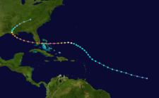
A tropical wave moved off the coast of Africa on August 14. Under the influence of a ridge of high pressure to its north, the wave tracked quickly westward. An area of convection developed along the wave axis to the south of the Cape Verde islands, and on August 15 meteorologists began classifying the system with the Dvorak technique. The thunderstorm activity became more concentrated, and narrow spiral rainbands developed around a developing center of circulation. On the basis of a Dvorak T-number of 2.0, it is estimated Tropical Depression Three developed late on August 16 about 1,630 miles (2,620 km) east-southeast of Barbados.[2]
Embedded within the deep easterlies, the depression tracked west northwestward at 20 miles per hour (32 km/h).[9] Initially, moderate wind shear prevented strengthening, though a decrease in shear allowed the depression to intensify into Tropical Storm Andrew at around 1200 UTC on August 17.[2] By early on August 18, the storm maintained concentrated convection near the center with spiral bands to its west as the winds increased to 50 miles per hour (80 km/h).[10] Shortly thereafter the thunderstorms decreased markedly during the diurnal minimum,[11] and as the storm turned to the northwest increased southwesterly wind shear from an upper-level low prevented Andrew from maintaining deep convection.[2] On August 19, a Hurricane Hunters flight into the storm failed to locate a well-defined center,[12] and the next day a flight found that the cyclone had degenerated to the extent that only a diffuse low-level circulation center remained; observations indicated the pressure rose to an unusually high 1015 mbar. The flight indicated Andrew maintained a vigorous circulation aloft, with winds of 80 miles per hour (130 km/h) recorded at flight level. Subsequently, the upper-level low weakened and split into a trough, which decreased the wind shear over the storm. Simultaneously, a strong high pressure cell developed over the southeastern United States, which built eastward and caused Andrew to turn to the west.[2] Convection became more organized as upper-level outflow became better established.[13] An eye formed, and Andrew attained hurricane status early on August 22 while located about 650 miles (1,050 km) east-southeast of Nassau, Bahamas.[2]
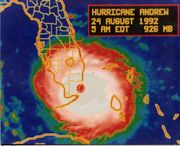
Six hours after becoming a hurricane, Andrew was predicted to make landfall near Jupiter, Florida with winds of 105 miles per hour (169 km/h).[14] The hurricane accelerated as it tracked due westward into an area of very favorable conditions, and late on August 22 began rapidly intensifying; in a 24 hour period the pressure dropped 47 mbar to a minimum pressure of 922 mbar.[2] On August 23 the cyclone attained Category 5 status on the Saffir-Simpson Hurricane Scale, and at 1800 UTC Hurricane Andrew reached peak winds of 175 miles per hour (282 km/h) while located a short distance off Eleuthera island in the Bahamas.[15] Operationally, the National Hurricane Center assessed its peak intensity as 150 miles per hour (240 km/h),[16] which was upgraded to 155 miles per hour (249 km/h) in post-analysis; the hurricane was re-classified as a Category 5 hurricane twelve years subsequent to the hurricane.[15] A small tropical cyclone, winds of 35 miles per hour (56 km/h) extended out only about 90 miles (140 km) from its center.[17] Subsequent to peaking in intensity, the hurricane underwent an eyewall replacement cycle,[18] and at 2100 UTC on August 23, Hurricane Andrew struck Eleuthera with winds of 160 miles per hour (260 km/h).[15] The cyclone weakened further while crossing the Bahama Banks, and at 0100 UTC on August 24 Andrew hit the southern Berry Islands of the Bahamas with winds of 150 miles per hour (240 km/h).[15] As it crossed over the warm waters of the Gulf Stream in the Straits of Florida, the hurricane rapidly re-intensified as the eye decreased in size and its eyewall convection deepened.[2] At 0840 UTC on August 24, Andrew struck Elliott Key with winds of 165 miles per hour (266 km/h) and a pressure of 926 mbar.[15] The hurricane continued to strengthen up to and slightly after landfall, and 25 minutes after its first Florida landfall Andrew hit near Homestead with a slightly lower pressure and winds over 150 mph.[2]
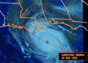
As the eye moved onshore, the convection in the eyewall strengthened owing to increased convergence, and Hurricane Hunters reported a warmer eyewall temperature than two hours prior. However, Hurricane Andrew weakened as the eye continued further inland, and after crossing southern Florida in four hours, the eye emerged into the Gulf of Mexico with winds of 135 miles per hour (217 km/h).[2] The eye remained well-defined as the hurricane turned to the west-northwest, a change due to the weakening of the ridge to its north.[19] Andrew steadily re-intensified over the Gulf of Mexico, reaching winds of 145 miles per hour (233 km/h) by late on August 25.[15] As the high pressure system to its north weakened, a strong mid-latitude trough approached the area from the northwest. This caused the hurricane to decelerate to the northwest,[2] and winds decreased as Andrew approached the Gulf Coast of the United States. At 0830 UTC on August 26 the cyclone made its final landfall in a sparsely populated area of Louisiana about 20 miles (32 km) west-southwest of Morgan City with winds of 115 miles per hour (185 km/h).[15] Hurricane Andrew weakened rapidly as it turned to the north and northeast, and within ten hours weakened to a tropical storm. After entering Mississippi, the cyclone deteriorated to tropical depression status early on August 27. Accelerating northeastward, the tropical depression began merging with the approaching frontal system, and by midday on August 28 Andrew ceased to meet the qualifications of a tropical cyclone while located over the southern Appalachian Mountains.[2] The remnants continued to the northeast and lost its identity within the frontal zone over the Mid-Atlantic states.[20]
Statistics
| Rank | Hurricane | Season | Landfall pressure |
|---|---|---|---|
| 1 | "Labor Day" | 1935 | 892 mbar (hPa) |
| 2 | Camille | 1969 | 909 mbar (hPa) |
| 3 | Katrina | 2005 | 920 mbar (hPa) |
| 4 | Andrew | 1992 | 922 mbar (hPa) |
| 5 | "Indianola" | 1886 | 925 mbar (hPa) |
| 6 | "Florida Keys" | 1919 | 927 mbar (hPa) |
| 7 | "Okeechobee" | 1928 | 929 mbar (hPa) |
| 8 | Donna | 1960 | 930 mbar (hPa) |
| 9 | Carla | 1961 | 931 mbar (hPa) |
| 10 | Hugo | 1989 | 934 mbar (hPa) |
| Source: National Hurricane Center | |||
Reports from private barometers helped establish that Andrew's central pressure, at landfall near Homestead, Florida, was 27.23 inches (922 hPa).[2] At the time, this was the third-lowest pressure on record for a landfalling hurricane in the United States (it is now fourth, after 2005's Hurricane Katrina).[21]
Andrew's peak winds in South Florida were not directly measured, primarily because of the destruction or failure of measuring instruments. The Coastal Marine Automated Network (C-MAN) station at Fowey Rocks, with platform elevation of 141 feet (43 m), in its last transmission at 4:30 a.m. EDT, August 24, recorded an 8-minute average wind of 142 miles per hour (229 km/h) with a peak gust of 169 miles per hour (272 km/h) shortly before the equipment was destroyed. It is probable that higher winds occurred at Fowey Rocks after the station was destroyed.[2]
Another important wind speed report came from the Kendall-Tamiami Executive Airport, located nine miles (14 km) west of the shoreline. While weather observations had been suspended at the station, the official weather observer there stayed on duty and continued to make wind speed readings. At 4:45 a.m. EDT, August 24, he noted that the wind speed indicator was "pegged" at a position a little beyond the instrument's highest value of 100 knots (190 km/h; 120 mph), at a point he estimated to be around 110 knots (200 km/h; 130 mph). The needle reportedly remained "fixed" at this location for 3–5 minutes before dropping to "0" when the anemometer failed. These observations were closely corroborated by two other observers. He also indicated that the weather conditions continued to worsen for an additional 30 minutes after the anemometer failed. It is probable that much stronger winds occurred at this location.[2]
The highest recorded surface gust, within Andrew's northern eyewall, occurred at the home of a resident about a mile from the shoreline in Perrine, Florida. During the peak of the storm, a gust of 212 miles per hour (341 km/h) was observed before both the home and anemometer were destroyed. Subsequent wind-tunnel testing at Clemson University of the same type of anemometer revealed a 16.5% error. The observed value was officially corrected to be 177 miles per hour (285 km/h).[2]
Data collected at the Turkey Point Nuclear Generating Station terminated at 5:05 EDT before winds reached maximum strength. The anemometer recorded sustained winds of 145 mph (220 km/h) before it failed, and a barometric pressure of 922 mb was recorded. Gusts exceeding 175 mph (280 km/h) were also observed. The data from Turkey Point reflects shoreline measurements (not inland), as it is situated directly on the coastline.[22] A National Weather Service-Miami Radar image recorded on 24 August 1992 at 4:35 EDT [08:35 UTC] superimposed on a street map by the Hurricane Research Division of NOAA clearly indicates the most powerful winds within the northern eyewall (conditions greater than 48 dBZ) made landfall between SW 152 St. (Coral Reef Drive) and SW 184 St. (Eureka Drive) in the Perrine/Cutler Ridge area.[23] dBZ readings indicate Decibels of Z (radar echo intensity/reflectivity) and help map the relative strength of storm activity within a weather system. This extremely powerful band within the northern eyewall corresponds with the exact latitude range where the highest surface wind gusts of 177 mph (248.8 km/h) and lowest barometric pressure was recorded at a private home in Perrine and evaluated by Clemson University.[2] This corridor is also in line with the former Burger King corporate headquarters, located on the shoreline at the terminus of 184th St. (Eureka Drive), where one of the highest storm surge levels was recorded (16.9 ft).[22]
In 2002, The Atlantic Basin Hurricane Database Reanalysis Project examined Hurricane Andrew and this corridor of extreme winds embedded within Andrew's northern eyewall. The project concluded that Category 5 conditions on land occurred only in a small region of southern Dade (now Miami-Dade) County, specifically close to the coast in Cutler Ridge. The remaining areas affected by Andrew's initial landfall in Florida likely experienced sustained Category 4 and 3 hurricane conditions. Andrew was officially re-classified as a Category 5 storm in 2004, and the reanalysis provides a more comprehensive and detailed examination of Andrew's wind field structure upon landfall than originally assessed in 1992.[15]
The National Hurricane Center, then located along U.S. 1 in Coral Gables, recorded a peak gust of 164 miles per hour (264 km/h) measured 130 feet (40 m) above the ground, just before 5 a.m. EDT. The anemometer was severely damaged at 5:17 a.m. EDT and by 5:45 a.m. had been completely destroyed.[2]
High winds occurred in other locations across Southern Florida, including peak gusts of 115 miles per hour (185 km/h) estimated at Miami International Airport and 132 miles per hour (212 km/h) recorded at Haulover Beach, Florida.[2]
In 2002, as part of an ongoing review of historical hurricane records, National Hurricane Center experts concluded that Andrew had sustained winds of 165 miles per hour (266 km/h) briefly before and during landfall, making it a Category 5.[2]
Berwick, Louisiana reported sustained winds of 96 miles per hour (154 km/h) with gusts to 120 miles per hour (190 km/h). The highest gust of 175 miles per hour (282 km/h) was reported from a drilling barge on Bayou Teche in coastal St. Mary Parish, Louisiana.[24]
Preparations
Bahamas
Before impact in the Bahamas predictions were for a 10 to 14 ft (4.3 m) storm surge, rising locally to 18 ft (5.5 m), and for 5 to 8 inches (200 mm) of rain.[25] Evacuations were ordered by emergency management officials, and at 5 PM local time residents throughout the region of Bahamas and Florida were warned to take precautions to protect life and property. On August 22 hurricane watches were issued from Andros and Eleuthera Islands northward through Grand Bahama and Great Abaco, they were upgraded to hurricane warnings later that day. On August 23 a hurricane warning was issued for Central Bahamas including Cat Island, Great Exuma, San Salvador, and Long Island. All watches and warnings were discontinued on August 24.[2]
United States
Florida
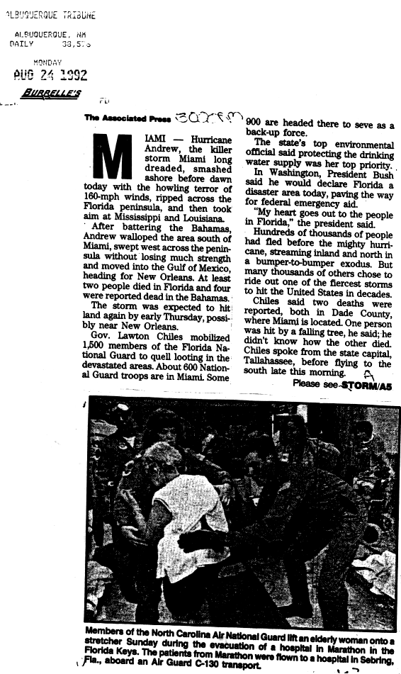
By 11 PM Eastern Standard Time, residents were warned that precautions to protect life and property should have been completed. About 55,000 people left the Florida Keys. Evacuations were ordered for 517,000 people in Dade County, 300,000 in Broward County, 315,000 in Palm Beach County and 15,000 in St. Lucie County. For counties further west in Florida, evacuation totals exceeding one thousand people are Collier (25,000), Glades (4,000) and Lee (2,500).[2] A 7 to 10-foot (3.0 m) storm surge was predicted for Eastern Florida and the Florida Keys, and a 7 to 11-foot (3.4 m) storm surge was predicted for Western Florida before the storm exited Florida. Some isolated tornadoes were also predicted for South and Central Florida for August 23 and August 24.[26] At least 1,500 National Guard troops were deployed to Florida to prevent looting.[27][28] Many hurricane watches and warnings were issued in Florida because of Hurricane Andrew. Including a hurricane warning issued on August 23, that stretched from Vero Beach, all the way to the Florida Keys and to Dry Tortugas. All watches and warning in the state were discontinued late on August 24 after Andrew moved offshore of Florida.[2]
Louisiana
Sandbag walls were created in the South Bell Telephone Building in New Orleans. Sandbag walls were also created in the French Quarter section of New Orleans. Floodgates were also closed throughout the New Orleans Levee system. Sandbags for the public ran out because of the protection of major areas. Planes headed to and from New Orleans were cancelled.[29] There were many watches and warnings issued because of Andrew. For about two days the entire southern coast of Louisiana was covered in warning and watches. All hurricane watches and warnings were discontinued after Andrew made landfall near Morgan City, Louisiana.[2]
Elsewhere
As Andrew approached the Gulf Coast, tropical storm/hurricane watches and warnings were also issued in Alabama, Mississippi, and Texas. All watches and warnings were discontinued on August 25 after Andrew had moved inland over Louisiana.[2]
Aftermath and Impact
| Rank | Hurricane | Season | Cost (2005 USD) |
|---|---|---|---|
| 1 | "Miami" | 1926 | $157 billion |
| 2 | "Galveston" | 1900 | $99.4 billion |
| 3 | Katrina | 2005 | $81.0 billion |
| 4 | "Galveston" | 1915 | $68.0 billion |
| 5 | Andrew | 1992 | $55.8 billion |
| 6 | "New England" | 1938 | $39.2 billion |
| 7 | "Cuba–Florida" | 1944 | $38.7 billion |
| 8 | "Okeechobee" | 1928 | $33.6 billion |
| 9 | Donna | 1960 | $26.8 billion |
| 10 | Camille | 1969 | $21.2 billion |
| Main article: List of costliest Atlantic hurricanes | |||
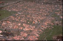
Florida
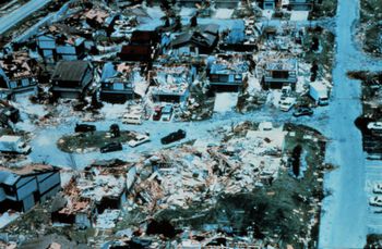
As with most high-intensity storms (Categories 4 and 5), the worst damage from Andrew is thought to have occurred not from straight-line winds but from vortices, or tornadoes or "miniwhirls" (something like embedded tornadoes). This was the conclusion of Tetsuya Theodore Fujita, a University of Chicago meteorologist who is known for the development of the Fujita scale for measuring the strength of tornadoes.
Looting also occurred in Florida after the storm, with at least 100 people attempting to ransack the Cutler Ridge shopping mall south of Miami. However, the deployment of 600 National Guard troops in the region restored order.[27]
Andrew produced a 17 feet (5.2 m) storm surge near the landfall point in Florida. A tidal surge of 16.9 feet (5.2 m) was recorded at the shoreline of SW 184th Street (Eureka Drive), the former location of the Burger King world corporate headquarters on the coast of the Perrine/Cutler Ridge area (directly within the path of the northern eyewall).[22] Storm surge destruction was minimal, though, because of Andrew not moving over Miami itself.
Rainfall was limited in Southeast Florida because of Andrew traveling through at fast speeds (between 20 and 25 mph forward speed).
| Costliest U.S. Atlantic hurricanes Cost refers to total estimated property damage. |
|||||
|---|---|---|---|---|---|
| Rank | Hurricane | Season | Damages | 2011 USD | |
| 1 | Katrina | 2005 | $81 billion | $91.1 billion | [31] |
| 2 | Andrew | 1992 | $26.5 billion | $41.5 billion | [31] |
| 3 | Ike | 2008 | $29.6 billion | $30.2 billion | [32] |
| 4 | Wilma | 2005 | $20.6 billion | $23.2 billion | [31] |
| 5 | Charley | 2004 | $18.6 billion | $17.4 billion | [31] |
| Main article: List of costliest Atlantic hurricanes | |||||
Unlike most hurricanes, the vast majority of the damage in Florida was due to the winds. The agricultural loss in Florida was $1.04 billion alone.[33]
In Dade County 90% of homes had major roof damage. 117,000 were destroyed or had major damage.[33]
The Turkey Point Nuclear Generating Station was hit directly by Andrew. Over $90 million of damage was done, largely to a water tank and to a smokestack of one of the fossil-fueled units on-site, but the containment buildings were undamaged. The nuclear plant was built to withstand winds of up to 235 mph.
Massive damage caused by Andrew at Homestead Air Force Base, very near the point of landfall on the South Florida coast, led to the closing of the base as a full active-duty base. It was later partly rebuilt and operates today as a U.S. Air Reserve base. The aircraft and squadron were relocated to Aviano Air Base in Italy.
Power lines to the Florida Keys were destroyed, leaving residents without power. However, water was maintained, although it had to be boiled.[34]
There was also moderate damage to the coral reef areas offshore of Florida down to depths of 75 feet (23 m).[33]
Andrew's catastrophic damage spawned many rumors, including claims that hundreds or even thousands of migrant farm workers in south Dade County (now Miami-Dade County) were killed and their deaths were not reported in official accounts. An investigation by the Miami Herald found no basis for such rumors. These rumors were probably based on the 1928 Okeechobee Hurricane, when the deaths of migrant workers initially went uncounted, and were still debated at the time of Andrew.
The slow response of federal aid to storm victims in southern Florida led Dade County emergency management director Kate Hale to famously exclaim at a nationally televised news conference, "Where in the hell is the cavalry on this one? They keep saying we're going to get supplies. For God's sake, where are they?" Almost immediately, President George H. W. Bush promised, "Help is on the way," and mobile kitchens and tents, along with units from the 82nd Airborne Division, began pouring in.[35]
Insurance claims in the wake of the extreme damage caused by Andrew led to the bankruptcy and closure of 11 insurance agencies and drained an excessive amount of equity from 30 more. An estimated $16 billion of the total losses (mainly structural) were insured. The Federal Insurance Administration estimated that flood damage from the hurricane would total $100 million and that the program would cover all expected claims.[36] Even though a state-managed catastrophe fund was implemented to provide protection for the industry and its consumers, insurance rates and deductibles drastically increased.[37] Nearly one million residences were no longer eligible for coverage by any insurance agency. This led the Florida Legislature to create new agencies (the Joint Underwriting Association, the Florida Windstorm Underwriting Association and the Florida Hurricane Catastrophe Fund) to restore adequate insurance coverage.
Homeowners and officials criticized developers and contractors for inadequate building practices and poor building codes. An inquiry after the storm concluded that there were probably construction flaws in some buildings, and that the state of Florida did enforce some strict building codes since 1986, but they were either overlooked or ignored.[38]
The effects of Hurricane Andrew on Florida wetlands were considerable. In the Florida Everglades, 25%, 70,000 acres (280 km2) of trees were knocked down by the storm. It took 20 days for new trees and vegetation to grow following the storms passing. Damage to marine life was moderate as the storm increased the turbidity and lowered the oxygen level in the water, threatening many fish and other marine wildlife. In addition, the storm killed 182 million fish in the basin, causing $160 million (1992 USD) in lost value.[39] In the decade after the storm, Hurricane Andrew may have contributed to the massive and sudden housing boom in Broward County, Florida. Located just north of Miami-Dade County, residents who had lost their homes migrated to western sections of the county that were just starting to be developed. The result was record growth in places like Miramar, Pembroke Pines and Weston.[39]
Louisiana
After hitting Florida, Andrew moved across the Gulf of Mexico and once again made landfall in south-central Louisiana.[40] About 152,000 electricity customers lost their power because of the impact of Andrew. Four people were also killed as a result of Andrew.
Storm tides of at least eight ft (2.4 m) inundated portions of the Louisiana coast. Andrew also produced a killer tornado in southeastern Louisiana. The F3 tornado hit Laplace and stayed on ground until Reserve, St. John the Baptist Parish. The tornado caused two deaths.[24]
Damage was done to soy bean, corn, and sugar cane crops. The damage estimated done to the sugar cane was $200 million.[41]
A Coast Guard helicopter had to rescue 4 people and 2 dogs from a disabled 65-foot (20 m) fishing boat, 50 miles (80 km) south of Houma.[29]
In Louisiana, the hurricane knocked down 80% of the trees in part of the Atchafalaya River Basin near the coast. Offshore, the storm killed 9.4 million fish, causing $7.8 million (1992 USD) in lost value, and damaged large areas of marshland along the Louisiana coast.[39]
About 6,200 people had to be housed in 36 separate shelters, according to the American Red Cross. The Salvation Army sent in 37 mobile food storage faculties, that served 40,000 meals, to help those who could get little or no food.
Federal aid, from the Pentagon, sent in four 750 kilowatt generators, 2,500 cots, and 30,000 MRE's, or prepackaged meals, to Louisiana. About 1,279 National Guard were deployed to Louisiana, to do various duties, from cooking to patrolling.[41]
Sheriffs along the coast of Louisiana imposed a curfew from 6 p.m. to 6 a.m. local time. Alcohol sales were also banned immediately after the storm.[29]
Retirement
Because of the exceptional and widespread damage in Florida and Louisiana, the name Andrew was retired in the Spring of 1993, and will never again be used for an Atlantic hurricane.[42] The name was replaced by Alex for the 1998 season.
Notes
- ↑ "Hurricane Andrew". Coastal Services Center. http://www.csc.noaa.gov/crs/cohab/hurricane/andrew/andrew.htm. Retrieved 2008-04-10.
- ↑ 2.00 2.01 2.02 2.03 2.04 2.05 2.06 2.07 2.08 2.09 2.10 2.11 2.12 2.13 2.14 2.15 2.16 2.17 2.18 2.19 2.20 2.21 2.22 2.23 2.24 Rappaport, Ed. "Preliminary Report". National Hurricane Center. http://www.nhc.noaa.gov/1992andrew.html. Retrieved 2008-04-10.
- ↑ Dunn, Gordon (1961). "Hurricane Season of 1960". NOAA. http://www.nhc.noaa.gov/archive/storm_wallets/atlantic/atl1960/donna/prenhc/. Retrieved 10 May 2010.
- ↑ Dunn, Gordon (1965). "Hurricane Season of 1964". NOAA. http://www.aoml.noaa.gov/general/lib/lib1/nhclib/mwreviews/1964.pdf. Retrieved 10 May 2010.
- ↑ "Hurricane Betsy Preliminary Report". U.S. Department of Commerce. 1965. http://www.nhc.noaa.gov/archive/storm_wallets/atlantic/atl1965/betsy/prenhc/. Retrieved 10 May 2010.
- ↑ "Hurricane Elena Preliminary Report". National Hurricane Center. 1985. http://www.nhc.noaa.gov/archive/storm_wallets/atlantic/atl1985-prelim/elena/prelim01.gif. Retrieved 10 May 2010.
- ↑ Case, Robert (December 10, 1985). "Hurricane Kate Preliminary Report". National Hurricane Center. http://www.nhc.noaa.gov/archive/storm_wallets/atlantic/atl1985-prelim/kate/prelim01.gif. Retrieved 10 May 2010.
- ↑ "Miami-Fort Lauderdale-Miami Beach, FL MSA Population". Texas A&M University. 2009. http://recenter.tamu.edu/data/popm00/pcbsa33100.html. Retrieved 10 May 2010.
- ↑ Mayfield (1992). "Tropical Depression Three Discussion One". National Hurricane Center. http://www.nhc.noaa.gov/archive/storm_wallets/atlantic/atl1992/andrew/tropdisc/nal0492.001. Retrieved 2007-08-27.
- ↑ Rappaport (1992). "Tropical Storm Andrew Discussion Five". National Hurricane Center. http://www.nhc.noaa.gov/archive/storm_wallets/atlantic/atl1992/andrew/tropdisc/nal0492.005. Retrieved 2007-08-27.
- ↑ Gerrish (1992). "Tropical Storm Andrew Discussion Eight". National Hurricane Center. http://www.nhc.noaa.gov/archive/storm_wallets/atlantic/atl1992/andrew/tropdisc/nal0492.008. Retrieved 2007-08-27.
- ↑ Lawrence (1992). "Tropical Storm Andrew Discussion Thirteen". National Hurricane Center. http://www.nhc.noaa.gov/archive/storm_wallets/atlantic/atl1992/andrew/tropdisc/nal0492.013. Retrieved 2007-08-27.
- ↑ Mayfield (1992). "Tropical Storm Andrew Discussion Twenty". National Hurricane Center. http://www.nhc.noaa.gov/archive/storm_wallets/atlantic/atl1992/andrew/tropdisc/nal0492.020. Retrieved 2007-08-27.
- ↑ Mayfield (1992). "Hurricane Andrew Discussion Twenty-Three". National Hurricane Center. http://www.nhc.noaa.gov/archive/storm_wallets/atlantic/atl1992/andrew/tropdisc/nal0492.023. Retrieved 2007-08-28.
- ↑ 15.0 15.1 15.2 15.3 15.4 15.5 15.6 15.7 Christopher Landsea, et al. (2004). "A Re-Analysis of Hurricane Andrew's Intensity". American Meteorological Society. http://www.aoml.noaa.gov/hrd/Landsea/landseabams2004.pdf. Retrieved 2007-08-28.
- ↑ Mayfield (1992). "Hurricane Andrew Discussion Thirty". National Hurricane Center. http://www.nhc.noaa.gov/archive/storm_wallets/atlantic/atl1992/andrew/tropdisc/nal0492.030. Retrieved 2007-08-28.
- ↑ Chris Landsea (2004). "Aren't big tropical cyclones also intense tropical cyclones?". Hurricane Research Division. http://www.aoml.noaa.gov/hrd/tcfaq/C3.html. Retrieved 2007-08-28.
- ↑ Rappaport, Gerrish, & Pasch (1992). "Hurricane Andrew Discussion Thirty-One". National Hurricane Center. http://www.nhc.noaa.gov/archive/storm_wallets/atlantic/atl1992/andrew/tropdisc/nal0492.031. Retrieved 2007-08-28.
- ↑ Avila & Mayfield (1992). "Hurricane Andrew Discussion Thirty-Five". National Hurricane Center. http://www.nhc.noaa.gov/archive/storm_wallets/atlantic/atl1992/andrew/tropdisc/nal0492.035. Retrieved 2007-08-28.
- ↑ David Roth (2007). "Rainfall Summary for Hurricane Andrew". Hydrometeorological Prediction Center. http://www.hpc.ncep.noaa.gov/tropical/rain/andrew1992.html. Retrieved 2007-08-29.
- ↑ Knabb, Richard D; Rhome, Jamie R.; Brown, Daniel P (December 20, 2005; updated August 10, 2006). "Tropical Cyclone Report: Hurricane Katrina: 23–30 August 2005" (PDF). National Hurricane Center. http://www.nhc.noaa.gov/pdf/TCR-AL122005_Katrina.pdf. Retrieved 2006-05-30.
- ↑ 22.0 22.1 22.2 NOAA.gov
- ↑ NOAA.gov
- ↑ 24.0 24.1 David Roth (2010-01-14). "Louisiana Hurricane History". Hydrometeorological Prediction Center. p. 47. http://www.hpc.ncep.noaa.gov/research/lahur.pdf. Retrieved 2010-03-28.
- ↑ Mayfield (1992). "Hurricane Andrew Advisory 30". National Hurricane center. http://www.nhc.noaa.gov/archive/storm_wallets/atlantic/atl1992/andrew/public/pal0492.030. Retrieved 8 May 2010.
- ↑ Rappaport/Gerrish/Pasch (1992). "Hurricane Andrew Advisory 31". National Hurricane Center. http://www.nhc.noaa.gov/archive/storm_wallets/atlantic/atl1992/andrew/public/pal0492.031. Retrieved 8 May 2010.
- ↑ 27.0 27.1 "(Newspaper Upload "at0824p3")". http://www.nhc.noaa.gov/archive/storm_wallets/atlantic/atl1992/andrew/news/ap0824p3.gif.
- ↑ "(Newspaper Upload "at0824p1"". http://www.nhc.noaa.gov/archive/storm_wallets/atlantic/atl1992/andrew/news/at0824p1.gif.
- ↑ 29.0 29.1 29.2 "(The Inteligencer Summary of Impact (The Inteligencer)". http://www.thehurricanearchive.com/Viewer.aspx?img=26525313&firstvisit=true¤tResult=1¤tPage=0.
- ↑ Pielke, Roger A., Jr.; et al. (2008). "Normalized Hurricane Damage in the United States: 1900–2005" (PDF). Natural Hazards Review 9 (1): 29–42. doi:10.1061/(ASCE)1527-6988(2008)9:1(29). http://forecast.mssl.ucl.ac.uk/shadow/docs/Pielkeetal2006a.pdf.
- ↑ 31.0 31.1 31.2 31.3 Eric S. Blake, Edward N. Rappaport, Christopher W. Landsea (2007-04-15). "The Deadliest Costliest, and most intense United States Tropical Cyclones from 1851 to 2006 (and other frequently requested hurricane facts)". National Hurricane Center. National Oceanic and Atmospheric Administration. http://www.nhc.noaa.gov/pdf/NWS-TPC-5.pdf. Retrieved 2010-05-03.
- ↑ Robbie Berg (2010-05-03). "Tropical Cyclone Report: Hurricane Ike". National Hurricane Center. National Oceanic and Atmospheric Administration. http://www.nhc.noaa.gov/pdf/TCR-AL092008_Ike_3May10.pdf. Retrieved 2010-05-03.
- ↑ 33.0 33.1 33.2 John M. Williams, Iver W. Duedall et Fred Doehring (1997). Florida Hurricanes and Tropical Storms. University Press of Florida. ISBN 0-8130-2417-X.
- ↑ Swanson and Wilkinson. "Florida Keys Hurricanes of the Last Millennium". Keys Historeum. http://www.keyshistory.org/hurricanelist.html. Retrieved 8 May 2010.
- ↑ Adair (2002). "10 years ago, her angry plea got hurricane aid moving". St. Petersburg Times. http://www.sptimes.com/2002/webspecials02/andrew/day3/story1.shtml. Retrieved 8 May 2010.
- ↑ Pear, R. Hurricane Andrew: Breakdown seen in U.S. storm aid. The New York Times. August 29, 1992, p. 1.
- ↑ Hopper (2005). "An American History of Disaster and Response". National Public Radio. http://www.npr.org/templates/story/story.php?storyId=4839530. Retrieved 8 May 2010.
- ↑ Sainz (2002). "Ten years after Hurricane Andrew, effects are still felt". St. Petersburg Times. http://www.sun-sentinel.com/news/weather/hurricane/sfl-1992-ap-mainstory,0,913282.story. Retrieved 8 May 2010.
- ↑ 39.0 39.1 39.2 Lovelace and McPherson (1998). "Effects of Hurricane Andrew (1992) on Wetlands in Southern Florida and Louisiana". U.S. Geological Survey. http://water.usgs.gov/nwsum/WSP2425/andrew.html. Retrieved 8 May 2010.
- ↑ McCown (2009). "Hurricane Andrew 1992". National Climatic Data Center. http://lwf.ncdc.noaa.gov/oa/satellite/satelliteseye/hurricanes/andrew92/andrew.html. Retrieved 8 May 2010.
- ↑ 41.0 41.1 "(The Inteligencer)". http://www.thehurricanearchive.com/Viewer.aspx?img=26418438&firstvisit=true¤tResult=4¤tPage=0.
- ↑ National Hurricane Center (2009). "Retired Hurricane Names Since 1954". National Oceanic and Atmospheric Administration. http://www.nhc.noaa.gov/retirednames.shtml. Retrieved 2009-09-13.
See also
- List of Category 5 Atlantic hurricanes
- List of Florida hurricanes
- List of retired Atlantic hurricane names
- Timeline of the 1992 Atlantic hurricane season
- Hurricane Andrew, South Florida and Louisiana, August 23–26, 1992, report on the event by the NOAA Disaster Survey Team
References
- Modified after the National Hurricane Center web site. This U.S. government site is in the public domain.
Further reading
- Sherrow, Victoria (1998). Hurricane Andrew:
Nature's Rage. Enslow. ISBN 0766010570.
External links
|
||||||||||||||||||||
|
||||||||||||||||||||||||||
|
|
|||||||||||||||||||||||||